Here is the latest information on the wildfires burning in Colorado.
COLORADO, USA — Firefighters are battling multiple wildfires everywhere from northwestern Colorado to near the Four Corners.
The fires have been reported as weekend temperatures continued to be forecasted as hot and dry, and after a heat wave led to three days in a row of triple digits along the Front Range.
We have a roundup of all the Colorado wildfires below.
RELATED: Camping this weekend? Here are the Colorado counties with fire bans
RELATED: In spite of wildfire risk, there’s no statewide guide book for building property in Colorado
Sylvan Lake State Park Fire
Location: 12 miles south of Eagle
Eagle Valley Wildland Fire Protection Service said Sunday afternoon that Sylvan Lake State Park, Yeoman Park and Crooked Creek Pass are under an evacuation order.
The fire is running, crowning and spotting in continuous fuels, according to Eagle Valley Wildland. Crews from Greater Eagle Fire Protection District, Eagle River Fire Protection District and the U.S. Forest Service are on scene.
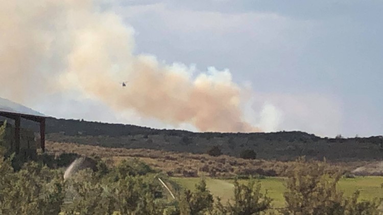
Frying Pan Road Fire
Pitkin County Sheriff’s Office said Sunday afternoon it is aware of a wildfire burning in steep terrain in the area of mile marker 11 on Frying Pan Road.
A helicopter is dropping water on the fire and a federal wildland crew is also responding.
Middle Mountain Fire
Moffat County Sheriff’s Office said Sunday afternoon that crews are responded to a wildfire on Middle Mountain in the northwest corner of the county.
Moffat County Roads 72 and 167 are currently closed, and people are asked to avoid the area.
Mt. Falcon Fire
Location: Mt. Falcon Park
Lightning sparked a 1 acre wildfire at the popular Mt. Falcon Park near Morrison on Saturday afternoon.
Firefighters from Foothills Fire and Indian Hills Fire were called to the scene.
The Jefferson County Sheriff’s Office tweeted Saturday evening that helicopter drops had saturated the fire, but smoke would likely still be seen Sunday.
Mt. Falcon Park reopened on Sunday morning. The sheriff’s office said Sunday afternoon that helicopters were dumping more water after the fire grew 0.25 acres since Saturday night. There were active flames as of 5:30 p.m., and the west side of the park was closed again.
Oil Springs Fire
Location: 20 miles south of Rangely
The lightning-sparked Oil Springs Fire was first seen in a remote Wilderness Study Area off Highway 139 in the Texas Mountain area, according to the Rio Blanco County Sheriff’s Office.
An evacuation order is in effect until at least 8 p.m. Monday from the Garfield County line to Rio Blanco County Road 116 on the west side of Highway 139 and Rio Blanco County roads 27, 28 and 120 on the east side of the road. The evacuation point is the Rangely Latter Day Saints Church at 125 Eagle Crest St. Only the northbound lanes of Highway 139 are open.
Smith Gulch Fire
Location: Northeast of De Beque
The Smith Gulch Fire is the largest of multiple possibly lightning-sparked fires along the Interstate 70 corridor on the Western Slope, according to Upper Colorado River Interagency Fire Management.
This fire is visible from I-70, but it’s not immediately clear whether any structures are threatened.
Snowmass Canyon Fire
Location: Mile marker 1 of Lower River Road, east of Snowmass
This fire is burning on federal land in steep and difficult terrain.
Saturday morning, seven firefighters from Roaring Fork Rescue and seven more firefighters from the Bureau of Land Management were airlifted to the scene, with helicopter drops planned throughout the day.
Saturday evening, the fire was declared contained and under control. A small crew of firefighters were kept on scene to watch for hot spots overnight.
There is no word yet on what sparked this fire.
A Red Flag Warning was issued for Pitkin County and much of the Western Slope.
North Cinder Butte Area Fires
Eighteen fires broke out on Friday on the Southern Ute Indian Reservation, south of Durango, according to authorities.
Lightning sparked the North Cinder Butte Area Fires throughout the west side of the reservation, prompting a response from multiple agencies, according to the Durango Interagency Coordinating Group (DICG).
The tribe was coordinating with local agencies on public safety and to minimize the impact of the fires. It was also working with oil-and-gas operators in the area to shut-in facilities in the vicinity of the fire, DICG said in a news release.
RELATED: Lightning sparks 18 fires on Southern Ute Indian Reservation
SUGGESTED VIDEOS: Latest from 9NEWS